DATE FROM -3700/STONEHENGE IN THE UK (PRESELI, AVEBURY AND STONEHENGE HILLS)
DESCRIPTION OF THE OVERALL SITE INCLUDING STONEHENGE AND AVESBURY
Stonehenge is the most architecturally sophisticated prehistoric stone circle in the world, while Avebury is the largest
These are two chalky geological areas in southern Britain in which ceremonial and funerary monumental complexes and sites associated with the Neolithic and Bronze Age were built.
” … ” The landscapes of Avebury and Stonehenge are vast – both representing about 25 km2 – and they illustrate well the relationships between the monuments as well as their landscape environment. ” … “
Each area contains a central circle of megaliths and many other monuments.
At Stonehenge, these include the Avenue, the Cursus, Durrington Walls, Woodhenge and the largest concentration of burial mounds in Britain. At Avebury, they include Windmill Hill, West Kennet Long Mound (the largest known Neolithic mass grave in southern England), the Sanctuary, Silbury Hill, West Kennet and Beckhampton Avenues (West Kennet Avenue connects the stone circle to the sanctuary 2km away), West Kennet Palisades and large burial mounds.
https://whc.unesco.org/fr/list/373/
AVESBURY
The fact is that elements of the Avebury site are much older than Stonehenge: the long mound of West Kenneth dates from – 3 700, Windmill hill dates from – 3 300, the site of the Sanctuary dates from – 3 000 and would have been finalized at the time of the creation of the sacred circle of Avebury, Sill Bury hill dates from – 2 750/-2 400, as for Avebury it dates from – 2 600, which corresponds to phase 1 of the construction of Stonehenge (of which we will see afterwards the details of the phases and their dating).
So that before speaking about Stonehenge, it seems preferable to speak first about the site of Avebury which precedes it, if we want to understand it better.
If Avesbury is obviously the center, the epicenter of the cult of this specific area, it is necessary to consider it as a whole with its most obvious immediate connected sites.
Here is what we can read about the number of burial mounds on the Avebury site and the interpretation that researchers have.
Archaeologists Joshua Pollard and Andrew Reynolds have noted that in the mid-fourth millennium BC, the landscape around Avebury “was stealthily changing. the landscape around Avebury was “stealthily changing. Some 30 Early Neolithic long barrows are known from the northern Wiltshire highlands, 17 of which were definitely or probably chambered, the others not chambered. There may have been more than this in the early Neolithic, with various examples destroyed by agricultural activity in the intervening millennia. Those that survive are spread relatively evenly over the area of northern Wiltshire measuring about 20 kilometers by 15 kilometers, with Avebury near the center of this distribution.
https://en.wikipedia.org/wiki/West_Kennet_Long_Barrow
Early Neolithic British communities placed a greater emphasis on ritual burial of the dead than their Mesolithic ancestors. Archaeologists have suggested that this was because Early Neolithic Britons adhered to an ancestor cult that worshipped the spirits of the dead, believing that they could intercede with the forces of nature for the good of their living descendants. It has been suggested that early Neolithic people entered tombs – which also served as temples or shrines – to perform rituals honoring the dead and asking for their help. For this reason, historian Ronald Hutton has called these monuments “tomb-sanctuaries” to reflect their dual purpose.
https://en.wikipedia.org/wiki/West_Kennet_Long_Barrow
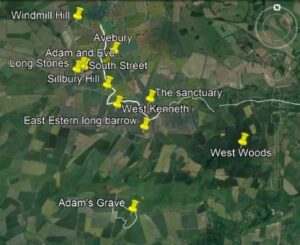
AVEBURY AND RELATED SITES
Here is a Google image of the different sites around Avebury
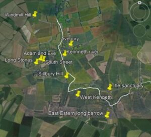
Google Imaging
In white, the course of the Kenneth River, which gives its name to one of the two avenues that link Avebury to the Sanctuary (named here Sanctuary).
Do not confuse the longstone long barrow (here called Longstone) and the Longstones “Adam and Eve” a little further north.
the site of the sacred circle or cromlech of avebury
The Avebury cromlech is the largest in Europe. It dates back to about 5,000 years (around 2,600 BC): it is older than the site of Stonehenge, which is located about 40 km to the south.
The central site of Avebury is made up of several megalithic complexes of exceptional scale: a huge cromlech surrounding a village of the same name and two other smaller cromlechs, menhirs lined up to form two avenues, and other associated monuments, such as Silbury Hill, the largest burial mound in Europe, West Kennet Long Barrow, the largest covered burial ground in England, The Sanctuary (en) and Windmill Hill.
The circular monument consists of an enormous embankment bordered by a ditch of 1.3 km in circumference, inside which are 180 rough, locally quarried standing stones, forming the outer circle, and two smaller inner circles.
https://whc.unesco.org/fr/list/373/
The large outer circle “…” has a diameter of 335 m “…” and was originally composed of 98 stones, some of which weigh over 40 tons. The height of these stones varies between 3.6 and 4.2 meters. ” … ” The great circle is surrounded by a huge ditch, 21 m wide and 11 m deep, and a 9 m high embankment. Contrary to the great circle of Stonehenge I, the embankment is here outside the ditch, which excludes any defensive role to this ensemble.
The circle has four diametrically opposed entries in pairs: one N-N-W/S-S-E, the other E-N-E/O-S-W.
In the center of the outer circle are two other cromlechs. The northern circle measures 98 meters in diameter, although only a few stones remain. The southern circle, better preserved, has a diameter of 108 meters.
Few excavations have been undertaken at Avebury. ” … ” Their main tool was apparently antlers. ” … ” Few artifacts have been found, but human bones have been found scattered around the site.
Great interest has been shown in the shape of the Avebury stones. They are described as either very slender or short and stubby. The taller ones are considered to be the “males” and the shorter ones the “females”.
The human bones found by Gray indicate that the site may have played a role in funeral ceremonies or ancestor worship.
Avebury being a circular megalithic construction, the hypothesis of astronomical alignments has been put forward to explain the position of the stones
https://fr.wikipedia.org/wiki/Avebury
SITES RELATED TO AVEBURY
From two of its four entrances, West Kennet and Beckhampton Avenues, made of upright stones arranged in parallel, connect to other monuments scattered throughout the landscape.
https://whc.unesco.org/fr/list/373/
Indeed, from the circle of Avebury, a first avenue, the “Kenneth avenue (of the same name as the nearest river) which, by curving, joins the site of the Sanctuary to the south-east (with the nearby long mound of West Kenneth) while a second avenue, the Beckhampton Avenue, also joins the site of the Longstones of Beckhampton to the south-west (perhaps it extended beyond).
These two avenues, probably dating from the end of the Neolithic and the beginning of the Bronze Age, are alleys lined on both sides with two parallel rows of upright stones spaced at 15 m intervals.
Here is how William Stukeley, in 1743, represented the site (keeping Avebury to the north)
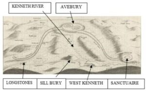
Illustration entitled “A Scenographic view of the Druid temple of Abury in north Wiltshire as in its original”. From “Abury, a temple of the British druids, and some others described” (London: 1743), by William Stukeley (1687-1765). Arc 855.214*, Houghton Library, Harvard University.
On the Longstones site, only one stone, known as “Adam”, remains standing and even in the time of William Stukeley (early 18th century),
Stukeley’s theory was that the two avenues were part of a giant “snake” snaking across the landscape with its head at the Sanctuary and also incorporating the Avebury monument.
https://en.wikipedia.org/wiki/Beckhampton_Avenue
Notice in Stukeley’s sketch that the Kenneth River abuts Avebury, and flows close to West Kenneth and the shrine.
Notice also that Stukeley is sketching from the southwest and does not take much notice of Windmill hill which is in the background on the left.
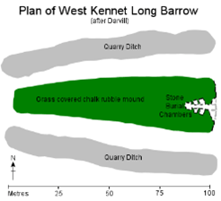
WEST KENNETH
The West Kennet Long Barrow, also known as the South Long Barrow, is a long mound with a cavity or chamber “…” probably built in 3,700 B.C., in the early British Neolithic period, it survives today in a partially reconstructed state.
http://www.stone-circles.org.uk/stone/westkennetbarrow.htm
It is part of a group of about thirty other similar tumuli centered on Avebury
” … ” Human bones were placed inside the chamber, probably between 3670 and 3635, then between 3620 and 3240 BC. During the Late Neolithic period, the entrance to the long mound was blocked by the addition of large blocks of sarsen. During the Late Neolithic and Early Bronze Age, the landscape around West Kennet Long Barrow was subject to widespread construction of ceremonial monuments, including the Avebury stone henge and circles, West Kennet Avenue, the shrine, and Silbury Hill.
It occupies a prominent place on the crest of a hill, just above the upper Kennet Valley.
It is possible that West Kennet Long Barrow was once a smaller monument that expanded during the Early Neolithic period.
Several of the long burial mounds uncovered in northern Wiltshire, such as those under South Street and Beckhampton Road, contained small structures prior to the erection of burial mounds at these sites. Pollard and Reynolds have suggested that these may have been “small” shrines.
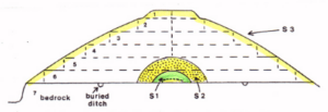
West Kennet Long Barrow is 100 meters long and 20 meters wide. Archaeologist Timothy Darvill noted that it was of “rather exceptional size,” being much larger than most long barrows.
The stone chamber has been characterized as “more elaborate” than most other examples in the Cotswold-Severn group. The chamber is constructed from sarsen and is tall enough to stand upright, which is a rare feature of long chambered burial mounds.
Please note what the two researchers noted:
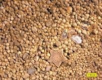
Pollard and Reynolds believed that the inclusion of stones in the mound was a deliberate choice made to “appropriate the stories and associations of these stones.” Oolitic limestone was also used in the drystone walls at West Kennet Long Barrow; it was also used in this manner at Adam’s Grave (another mound further south), while smaller fragments of this stone have been found in long, unchambered mounds at Shepherd’s Store, Easton Down, Horslip, and Kitchen Barrow. This stone does not occur naturally in this area of north Wiltshire, but would have had to be brought from the area around Frome and Bath. It is possible that it was chosen for inclusion in these monuments because of its associations with a distant place, because of its aesthetic qualities, or because it was believed to contain the essence of certain supernatural beings. It is also possible that the builders of these monuments considered the Cotswold region their ancestral homeland and that the use of oolitic limestone in these structures was a way to connect with their past.
https://en.wikipedia.org/wiki/West_Kennet_Long_Barrow
Here is what it says about oolite:
Oolite or oolite (egg stone) is a sedimentary rock formed of ooids, spherical grains composed of concentric layers. The name derives from the ancient Greek word for egg. Strictly speaking, oolites consist of ooids 0.25 to 2 millimeters in diameter; rocks composed of ooids larger than 2 mm are called pisolites. The term oolite can refer to an oolite or individual ooids.
Ooids on the surface of a limestone; Carmel Formation (Middle Jurassic) of southern Utah/Wikipedia
https://en.wikipedia.org/wiki/Oolite
Note that if the tumulus is long, the stone part serving as a sanctuary-tomb was in comparison reduced and at the extreme east.
LONGSTONE LONG BARROW
This monument is a long Neolithic mound aligned northeast to southwest and located on a gentle east-facing slope 300 m southwest of the long South Street mound. It “…” survives as an impressive earthwork that is 84 m long and 35 m wide. The mound rises to a height of 6 m and is flanked on the north and south by quarry ditches that provided the material for the mound’s construction. Evidence of a Bronze Age cremation burial contained in a pottery urn was discovered there.
https://historicengland.org.uk/listing/the-list/list-entry/1008126
THE LONGSTONES ” ADAM ” AND AND “EVE
The Longstones are two Sarsen stone menhirs, one of which is attributed to Beckhampton Avenue leading to the Longstones in the west
The avenue probably ended at this point, although it extended further southwest beyond the stones.
William Stukeley recorded the site in the 18th century when it was only partially destroyed and suggested that it extended further, although modern excavations and archaeological geophysics have not confirmed this.
These two stones, still visible, are locally called “Adam” and “Eve”, the “Longstone circle” or the “Devil’s phallus”.
The two stones are aligned southwest/northeast and are 3 m high.
“Eve” the least large/heavy, to the northeast, is considered to be probably a stone that was part of the Beckhampton Avenue that connected Avebury.
“Adam”, the larger of the two stones (approx. 62 tons), is the one to the southwest.
According to Stukeley, these two stones were part of a cove (a U) or circle, similar to the cove (a U) in Avebury’s northern inner circle, and located immediately adjacent to an avenue. In Stukeley’s time, this was represented by only about 30 stones, making the avenue line less clear than that of nearby West Kennet Avenue.
“Adam”, together with three others, formed a four-sided cove (a U).
Joint excavations by the Universities of Leicester, Newport, and Southampton University in 2000 revealed that the site holes for the other stones were closely placed near “Adam.” The cove was open on its southeast side, which faced the nearby South Street mound, 130 m away.
https://en.wikipedia.org/wiki/The_Longstones
https://historicengland.org.uk/listing/the-list/list-entry/1008104
WINDMILL HILL
With an area of 8.5 ha, Windmill Hill “is one of the largest recognized Neolithic enclosures in Britain.
The site appears to have been first occupied around 3800 B.C., suggested by a series of pits apparently dug by an agrarian society using Hembury-type pottery.
In a later phase, around 3300 B.C., three concentric segmented ditches were dug around the hilltop, with the outermost ditch having a diameter of 365 meters. ” … ” A Bronze Age burial mound was then constructed between the inner and central rings. ” … ” Large quantities of bone, both human and animal, were also recovered from the ditch fill.
https://fr.wikipedia.org/wiki/Windmill_Hill
SILLBURY HILL
Another exceptional monument, Silbury Hill is the largest tumulus in Europe. Built around 2400 BC, it stands 39.5 m high and contains half a million tons of chalk. The function of this imposing monument, so skilfully built, remains obscure.
https://whc.unesco.org/fr/list/373
http://www.stonehenge-avebury.net/aburysites.html
It is also a question of understanding that in fact of tumulus it is in reality a pyramid with degrees whose steps were then covered with ground
Composed primarily of chalk quarried from the immediate vicinity, the mound is 40 meters high2 and covers approximately 2.2 hectares, revealing immense technical knowledge, complemented by prolonged engineering skills in civil engineering, work organization, and procurement of a construction site of exceptional magnitude. Archaeologists estimate that Silbury Hill was built approximately 4,750 years ago and that it took 18 million man-hours, the efforts of 500 men over 15 years, to move and shape 248,000 cubic meters of fill material to complete a natural hill. Euan W. Mackie argues that no simple late Neolithic tribal structure, as is usually imagined, could have carried out such a project and others like it, and envisions an elite, authoritarian, theocratic power exercising vast control over all of southern Britain.
The base of the hill is circular, 167 m in diameter. The summit is flattened into a circular terrace of 30 m in diameter. A small tumulus was first built, considerably enlarged in a second time. The first structures at the base of the hill are perfectly circular, and measurements reveal that the center of the upper platform and the center of the base of the cone described by the hill are offset by only one meter from each other.
” … “William Stukeley writes that a skeleton and a bridle were discovered during a tree planting at the top of the monument in 1723: it was probably a late, secondary burial. ” … ” Silbury Hill revealed few prehistoric artifacts: its base yielded only clay, flint, turf, moss, topsoil, gravel, freshwater shells, mistletoe, oak, hazel, sarsen stones, ox bones, teeth, and antlers
https://fr.wikipedia.org/wiki/Silbury_Hill.
THE SANCTUARY
The sanctuary was a circle of stone and wood. ” … ” Excavations revealed the location of the 58 cells and 62 post holes. From its location on Overton Hill, the shrine offers views of various Early Neolithic monuments in the landscape, including West Kennet Long Barrow, East Kennet Long Barrow, and Windmill Hill.
It was connected “…” to Avebury via the West Kennet stone avenue. It is also close to the prehistoric Ridgeway and near several Bronze Age burial mounds. ” … ” Excavations revealed that the shrine consisted of two concentric rings with a total diameter of about 40 meters.
The first stage of activity at the site, circa 3000 BCE, consisted of a ring of eight wooden poles 4.5 meters in diameter, with a central pole, presumed to be a round hut. Within 200 years, the first ring was enlarged to 6 meters and a second ring was added, also of eight poles, but this time 11.2 meters, possibly creating a large hut or enclosure. Phase three, sometime in the later Neolithic, a third ring of 33 poles was added, in a circle 21 meters in diameter, and at the same time an inner stone circle of 15 or 16 sarsen stones was introduced next to what was at this point the middle ring, making an almost solid wall of stones and poles.
The final phase consisted of 42 sarsen stones forming a 40 meter diameter boundary ring, which replaced all wooden structures. This may have been built at a similar time to the Avebury stone circle and had an entrance that led to Kennet Avenue, two parallel lines of stones running the 2.5 kilometers from the shrine to Avebury.
EAST EASTERN LONG BARROW
The monument consists of a long mound located atop East Heslerton Wold. The mound lies along a narrow ridge that is slightly elevated above the surrounding land surface and it is believed that the mound was originally constructed to take advantage of this natural prominence.
OTHER NEARBY SITES
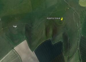
Among the sites in the vicinity of Avebury are Adam’s Grave and the White Horse Valley with the oldest Celtic geoglyph at the Huffington site.
ADAM’S GRAVE
Adam’s Grave was a long Neolithic burial mound near Alton Barnes in Wiltshire. The mound is considered to be of the Severn-Cotswol tomb type (like West Kenneth…). These are generally long trapezoidal earthen mounds built with precision covering the burial chambers, so they are a type of long chambered mound. The chamber, made of sarsen stones, contained partial human skeletons. ” … ” The area around Adam’s Tomb has a high density of long burial mounds and is important because of its archaeological potential.
The arrangement of stones around the site suggests that there was once a sidewalk or courtyard. They are known as ‘Old Adam and “Little Eve” and are located near the original entrance to the mound. ” … ” Associations with the nearby Avebury monument have also been suggested.
https://en.wikipedia.org/wiki/Adams_Grave.
Here is the location of the site in relation to Avebury:
And the Adam’s Grave website itself
Google image
Note that a white horse has been engraved (removing the surface to reveal the limestone) by an artist fairly recently. This recent engraving should not be confused with the much older one discussed below.
THE VALLEY OF THE WHITE HORSE…
The White Horse Valley corresponds to the valley of the Ock, a small river that flows into the Thames. ” … ” Its name is due to the White Horse of Uffington.
In addition, there is a grassy track claimed to be the oldest in Europe, The Ridgeway (en), dating back at least 5,000 years.
” … ” The richness of its green meadows and foliage contrasts with the bald peaks of the Berkshire Mountains, which border it to the south. The many elms, which were once an essential feature of the glen, have disappeared.” … “Traditionally, the Vale of the White Horse stretches from the Costwolds to the Berkshire Mountains.
” … ” To the west, above the village of Uffington, the hills reach their highest point (261 m) at White Horse Hill. On the north side of this hill, just below the summit, a gigantic white horse was drawn by digging out the white limestone soil. The drawing gave its name not only to the hill, but also to the surroundings and the valley. It is 114 meters long. It is very stylized, with the line of the neck, body, and tail of approximately constant width. The origin of the representation is unknown. ” … ” To the west of the hill is a kind of mound called “Wayland’s Smithy” (“Wayland’s Smithy”).
A grassy pathway represents the Ridgeway, recognized as the oldest road in Europe, dating back over 5,000 years. It runs along the ridges of the hills, high above what were then swampy plains and forests.
… WITH THE WHITE HORSE OF HUFFINGTON
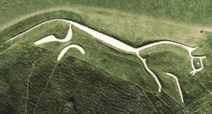
The Uffington White Horse is probably the oldest known chalk figure (geoglyph) in England. The silhouette of the horse is linear and traced in the chalk underlying the humus layer. The figure is inscribed in a rectangle 100 m by 30 m oriented north-south, head to south, and measures approximately 111 m from tail to ear. ” … “
A more recent dating, carried out in the 1990s by Simon Palmer and David Miles of the Oxford Archaeological Unit, nevertheless demonstrates that the figure dates from the Bronze Age. The gigantic white horse of Uffington, one of the largest human achievements of the European Bronze Age (± 3,000 years), is therefore, among the equine geoglyphs of England, probably the only one that can be linked to the Celtic civilization. Dated to the Final Bronze Age, it offers a schematic representation of the horse with an elongated body and disjointed legs, very close to what can be observed on Celtic coins. According to the most recent interpretation, the figure would not be a territorial symbol, representation of a local deity or figure drawn to honor the gods, but would be a horse “pulling the Sun”: a device related to the diurnal passage of the Sun in the sky, linked to the trajectory of the winter Sun, which is found in other Nordic countries.
https://fr.wikipedia.org/wiki/Cheval_blanc_d. Uffington
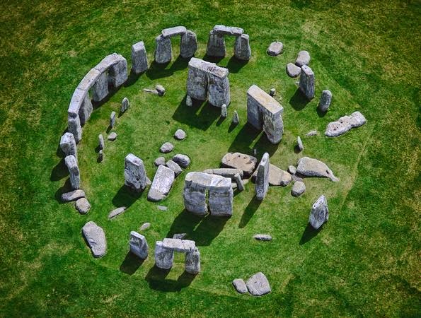
STONEHENGE
After having reviewed the elements of the Avebury site, it is appropriate to look at those of Stonehenge
DESCRIPTION
Stonehenge is the most architecturally sophisticated prehistoric stone circle in the world. It is unparalleled in its design and unique construction technique, with its huge lintel stones resting on the outer circle, and the triliths whose shapes fit together precisely. It is distinguished by the unique use of two different types of stones (bluestone and Sarsen), their size (the largest weighs over 40 tons), and the distances over which they were transported (up to 240 km). The sheer scale of some of the surrounding monuments is also remarkable; the Stonehenge Cursus and the Avenue are both about 3 km long, while Durrington Walls is the largest known stone circle in Britain, about 500 m in diameter, demonstrating the ability of prehistoric peoples to design, draw, and build structures of great size and complexity.
https://whc.unesco.org/fr/list/373/
Stonehenge is a megalithic monument composed of a set of concentric circular structures, erected between 2800 and 1100 BC, from the Neolithic to the Bronze Age.
https://fr.wikipedia.org/wiki/Stonehenge
LOCATION
It is located thirteen kilometers north of Salisbury, and four kilometers west of Amesbury (Wiltshire County, England).
The whole site of Stonehenge and the cromlech of Avebury, about 40 kilometers to the north, are inscribed on the UNESCO World Heritage List in a group entitled “Stonehenge, Avebury and associated sites”.
https://fr.wikipedia.org/wiki/Stonehenge
ETYMOLOGY
The meaning and etymology of Stonehenge remain somewhat uncertain: “hanging stones” or “overhanging stones” are appropriate for linguists familiar with Germanic roots, while “gallows” seems to be more of a folk etymology.
The name Stonehenge is attested as early as the Middle Ages: “…” authors of the eleventh century mention “stones which are not far from Salisbury”, under the names of stanenges or stanheng, understood as “supported stones”. (supported stones). In 1740, William Stukeley notes that ‘in Yorkshire, the hanging rocks are called henges… I have no doubt,’ he says, ‘that in Saxon Stonehenge means “hanging stones”. (hanging stones)’.
Christopher Chippindale, in his Stonehenge Complete, gives Stonehenge as possibly being derived from the Old English words stān “stone,” and hencg “hinge” (hinge in modern English), or from hen (c) en, in the sense of “gallows” or “instrument of torture”: the lintels and pillars of the triliths at Stonehenge may indeed have evoked for medieval visitors the familiar silhouette of a gallows. However, elsewhere in his book, Chippindale also gives Stonehenge the more immediate meaning of “suspended stones (suspended stones).
https://fr.wikipedia.org/wiki/Stonehenge
CHRONOLOGY AND DATING
The classic chronology is that of the archaeologist Richard J. C. Atkinson, who directed the last large-scale excavations from 1950 onwards and for some thirty years, with a major restoration campaign between 1958 and 1964.
We owe him the division into three phases I, II and III, now accepted by all. But the subdivisions, and sometimes even the entire chronology, differ significantly from one modern author to another.
The three phases are:
- Phase 1: From the Neolithic period, around 2800 / 2100 BC
- Phase 2: Chalcolithic, around 2100-2000 BC
- Phase 3: Bronze Age, ca. 2000 / 1100
Assuming that this phasing is correct, phase III is the site as we know it with its five U-shaped triliths surrounded by a belt of stones also in the shape of triliths.
This last phase is itself subdivided into four phases:
- Stonehenge III a (- 2 000)
- Stonehenge III b (-2 000 – 1 500)
- Stonehenge III c (- 1 550 -1 100)
- Stonehenge IV (- 1 100).
However, it is useful to note how the site has evolved over the millennia, so we will review the three phases.
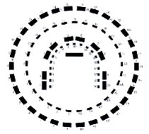
Before that, for the good understanding of the phases 1 and 2 I invite you to consult the following diagram provided by WK :
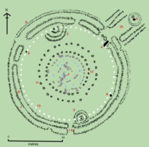
The plan omits the lintels of the trilithon for clarity. Holes that no longer or never contained stones are shown as open circles and stones visible today are shown in color, the “sarsen” sandstone megaliths are in gray, and the “blue stones” in blue.
1.the Altar Stone a six-ton monolith of green micaceous sandstone from Wales; 2 and 3. tumuli; 4. the Fallen Sacrifice Stone, 4.9 meters long; 5. the “Heel Stone (6. two of the four “station” stones; 7. Ditch 8. Inner bank 9. The outer bank; 10. The monumental “avenue,” a parallel pair of ditches and banks, leading to the Avon River, two miles to the east; 11. Ring of 30 pits called the Y-holes; 12. Ring of 29 pits called the Z-holes; 13. Ring of 56 pits, known as Aubrey’s holes; 14. Secondary entrance. The monument (cromlech) is located inside circle 12.
https://fr.wikipedia.org/wiki/Stonehenge
Let’s move on to what was done during the first two stages of construction:
Phase 1: From the Neolithic period, around 2800-2100 BC
with the creation :
- From the original circular outer enclosure (ditch and embankment)
- Aubrey’s holes:
The “Aubrey holes” are a vast circle of fifty-six large cavities, arranged regularly within and at a short distance from the slope of the circular enclosure. These round holes have vertical walls and are spaced about five meters apart. Their diameter varies from 0.75 m to 1.50 m, and their depth from 0.60 m to 1.20 m. Fragments of charcoal, charred human bones, small objects such as bone hairpins or long sticks of cut flint the thickness of a finger were found in a chalk filling, the use of which is not known. Thirty-four of them (eastern part) have been excavated. They are easily identifiable, marked by limestone plates.
- From the Heel Stone:
The Heel Stone (5), a Tertiary sandstone stone outside the northeast entrance, may also have been erected during this period, but it cannot be formally dated and may as well have been installed at any time during Phase III. One or two stones were attached to it (holes D and E).
The Heel Stone is similar in nature to the other “sarsens” of the central circle and the triliths (Phase III), but, unlike them, it is entirely rough, without any trace of cutting or tooling. It is currently leaning, in a position that cannot be its original one, and surrounded by a very marked ditch, located four meters from its base.
The name Heel Stone is attested since the Middle Ages. Its etymology and true meaning remain obscure: the word heel does not offer a satisfactory meaning, and etymologies evoking the “devil” or the “sun” have been used.
In Atkinson’s opinion, the Heel Stone is not as much of a marker as the builders intended to mark the exact direction of the rising sun at the summer solstice
- of the wooden structure A :
It is not known if these posts correspond to scaffolding, or if they supported the roof of one or more buildings
- Station Stones” perhaps at the end of this period:
The four Station Stones are small sarsen sandstone stones, located near the Aubrey holes and diametrically opposed two by two, the whole forming a long rectangle of NW-SE direction perpendicular to the general axis of the monument. Two of them remain, numbered (6) on the diagram above: they measure respectively 3 m and 1.20 m. The other two, marked in (2) and (3), were located at the top of mounds commonly called barrows (“tumulus”), although they do not contain burials. Ditches similar to the one encircling the Heel Stone were later dug around these two barrows
- From the burial enclosure to the southeast:
Several dozen smaller burial cavities, similar in content to the Aubrey holes and discovered not far from them, were excavated by Hawley in the southeastern half of the circular enclosure, which he completely stripped. In all, about 55 cremation graves were found, including the Aubrey Holes. Atkinson places this period of use as a cremation cemetery at the end of Phase I, spanning about two centuries. He suggests that additional graves may be found in the inner slopes of the enclosure, which have not been excavated. The presence of objects such as a club head or a small bowl partially burned on one side (a censer?) suggests that the deceased may have been political dignitaries or leaders with spiritual or religious authority, accompanied by their families…”
https://fr.wikipedia.org/wiki/Stonehenge
In SUMMARY of Phase I:
4,800 years ago (in 2,800 BC), the structure is thus a circle (ditch and embankment), within which is defined a first circle of 56 holes or pits (of sufficient diameter and depth to accommodate an adult (diameter of 1.5 m and depth of 1.2 m) or a child (diameter of 0.75 m and depth of 0.6). Bone hairpins, charcoal, charred bone remains, and flints the thickness of a finger were found. The Station stones form a rectangle perpendicular to the axis of the monument and more particularly of the entrance and the avenue. Two of these stones are on a tumulus and two others are not.
In the southeastern half of the enclosure, cremation graves were found. With the Aubrey holes, there are 55 cremation holes/pits.
Phase 2: Chalcolithic, around 2100-2000 BC
with the creation :
- Widening of the entrance roadway ” … “
- From the digging and filling of the Heel Stone ditch
- From the construction of the first section of the Avenue :
The “Avenue (10), 23 m wide (12 m between the embankments), starts from the Heel Stone in the axis of the monument, towards the northeast, then halfway to the Cursus, a long megalithic enclosure located a little further north, bends towards the east in a way that is very visible on aerial photographs and finally joins, three kilometers away and after a final right turn, the Avon River. This long structure is made up of two parallel ditches and the corresponding slopes established towards the interior, according to the characteristic technique of phase I, to which one may be tempted to relate it. It has all the appearance of a processional route, which probably also served to transport the “blue stones” from the river Avon.
- From the erection of the double circle of blue stones Q and R, unfinished :
two concentric circles, each consisting of 38 cavities named Q and R (Q and R holes), were dug in the center of the site, inside the current sarsen circle. In the axis of the monument, at the “entrance”, six additional cavities complete the ensemble, proving that the monument was already oriented to the northeast, towards the rising sun of the summer solstice, before the realization of the present structure (phase III).
These cavities have probably hosted more than eighty menhirs of “blue stones” constituting a first cromlech, entirely disappeared (theoretically: two concentric circles of 38 menhirs and 6 additional menhirs at the entrance, that is to say in all 82 megaliths).
Most of the “blue stones” still present on the site (reused during Phase III b) are made of dolerite, a greenish-blue holocrystalline magmatic rock with white or pinkish inclusions the size of a pea (spotted dolerite). But others are of a different nature: three of them are of similar dolerite, but without inclusions (unmottled dolerite); in addition, four blue stones are made of rhyolite (blue-gray volcanic rock) sometimes including whitish globules (spherulitic rhyolite); four buried stumps are made of an olive-green volcanic ash that is much softer and more brittle than all the other stones present on the monument; finally, two of them are of another kind of volcanic ash containing limestone. It has been known since 1923 that all these “blue stones” come from the Preseli Mountains (Pembrokeshire, Wales). Specifically, excavations conducted by Mike Parker Pearson in 2017 and 2018 showed that the bluestones at Stonehenge were probably from a now dismantled cromlech, named Waun Mawn, located in the Preseli Mountains.
https://fr.wikipedia.org/wiki/Stonehenge
In SUMMARY of Phase 2:
Around 2,100 years ago, the avenue was created, made up of two embankments, which runs from the entrance to the northeast to the Avon River, bending to the east halfway along.
Even if they were unfinished, there are also two circles of blue stones of 38 cavities each to which we must add the 6 of the entrance oriented to the North-East and the summer solstice, that is to say in all 82 megaliths.
If all bluestones are of volcanic origin, they are not of the same quality. Some are made of volcanic ash containing limestone, others of an olive green volcanic ash, others of rhyolite (blue-gray volcanic rock with or without whitish globules), others of dolerite (greenish-blue magmatic rock) spotted (with white or pinkish inclusions the size of a pea) and others of unspotted dolerite.
The bluestones of Stonehenge were probably taken from a now dismantled cromlech called Waun Mawn, located in the Preseli Mountains.
Phase 3: Bronze Age, ca. 2000 / 1100
The next stage of the work occurred at the end of the 3rd millennium, when the great period of megalithism was over all over Europe: all the blue stones of the circles Q and R were first removed and put aside, leaving the ground free for the new project.
One then sees erecting on the site an exceptional megalithic complex of seventy-five monoliths (at the origin), on which all the glances of the visitors are still concentrated today
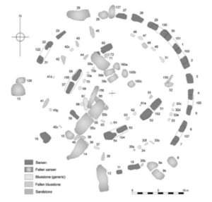
Before detailing the modifications made to the site in Phase III, here is the current state of the site followed by 2 reconstructions:
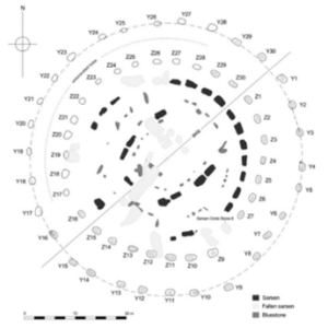
Here is the plan of the central cromlech, in its current state, with the official numbering of the stones:
- Outer circle of sarsen: stones 1 to 30 and lintels 101 to 130.
- Outer circle of blue stones: 31 to 49.
- Triliths of sarsen: stones 51 to 60 and lintels 152 to 160.
- Horseshoe of the blue stones: 61 to 72.
- “Altar stone”: 80.
https://fr.wikipedia.org/wiki/Stonehenge
Here is a plan seen from above of the reconstructed site:
The international journal of the humanities Volume 9, Number1, Reinventing the Past: John Wood the Elder by Tessa Morrison. P.47.
And a 3D view of the reconstructed site:
Hans Bernhard. 26/05/2010
Recomposed circle of blue stones and sarsen. By Alun Salt. (CC BY-SA 3.0)
What were the changes in Phase III?
Phase III a (- 2,000)
Those deemed to be Phase III a (- 2,000) include:
- Dismantling the double bluestone circle (Q and A of Phase II):
The next stage of the works occurs at the end of the 3rd millennium, when everywhere in Europe, the great period of megalithism is extinguished: all the blue stones of the circles Q and R are first removed and put aside, leaving the ground free for the new project (namely the erection of the 5 central triliths and those of the circumference, the final version that we know; see below)
- Transportation of sarsen blocks from the Marlborough area:
The huge monoliths, uniformly made of Oligocene-Miocene “sarsen” sandstone, were extracted from quarries that can be visited freely, about 40 km north of Stonehenge, in the Marlborough Downs, east of Avebury. ” … ” The transportation of these monoliths, the largest of which weigh about fifty tons, is an unparalleled collective engineering adventure. A hill in the middle of the route did not facilitate this operation, for which Atkinson proposed nothing more than sledges, ropes and wooden rollers, occupying thousands of men for decades.
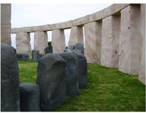
- The erection of the sarsen triliths:
The triliths are five groups of three monoliths of sarsen sandstone raised and arranged as porticoes in a horseshoe-shaped plan leaving a 13.70 meter wide opening to the northeast.
” … ” The triliths are arranged symmetrically: the two smallest pairs of triliths reached six meters in height, the next ones 6.50 meters, while the large single trilith on the SW side must have reached 7.3 meters in height, including the lintel. Starting from the NE opening in a clockwise direction, the first two triliths are the only ones that have survived intact, while the large central trilith has long since collapsed: “…”. The pillars of the triliths are arranged in pairs, spaced very close together; their profile decreases towards the top according to a curve that becomes more pronounced in the upper part, which is reminiscent of the principle of entasis in the ancient Greek temples, which gives the illusion of slender and straighter columns.
- The erection of the great circle of sarsen
The great circle of Sarsen sandstone is made up of thirty monoliths erected in a cromlech of thirty-three meters in diameter and surmounted by thirty lintels. Each pillar has two tenons corresponding to the two oval mortises of each of the lintels, which have been placed end to end by a precise assembly of grooves and tongues cut into points: the whole thus forms a continuous ring suspended at the top of the structure.
The final visual effect was the constant concern of the builders, as it was for the triliths: the orthostats (vertical stones) widen slightly upwards, so that, seen from the ground, their perspective remains constant, while the stone lintels are cut slightly curved, in order to preserve the general circular layout of the monument. Each pillar has its best face towards the inside of the circle. The carving is more rustic than that of the triliths and the outer faces are almost quarry rough. ” … ” The orthostats are nearly 4.10 meters high, 2.10 meters wide and weigh about twenty-five tons. The stone lintels, for their part, are each about 3.20 meters long, one meter wide, with a thickness of 0.80 meters: they weigh about seven tons. The tops of the lintels are suspended, for those which are still suspended, at 4,90 meters above the ground.
- The erection of the Slaughter Stone
The Slaughter Stone (4) is a fancy name given by ancient explorers to a carefully hewn sarsen stone, 7 m long, once raised, now fallen inwards from the monument, barely outcropping, near the embankment. It was part of the two, or perhaps three, large portals that marked the northeast entrance.
- Engravings executed after the erection of the sarsen.
https://fr.wikipedia.org/wiki/Stonehenge
SUMMARY OF PHASE III a:
There follows an apparent change of project since the two central concentric circles of bluestones are removed to leave the place to a new project which will consist in the elevation of the 5 central triliths and the perimeter, also in trilith. These triliths are made of Sarsen sandstone and come from the Marlborough Downs, east of Avebury (a site linked to Stonehenge).
The central triliths are spaced out and form a horseshoe whose opening is in the northeast, facing the main entrance. The main trilith is 7.3 m, the two others around 6.5 m and the last two 6 m.
The circle is composed of 30 triliths joined together by mortises and tenons forming a ring. At the entrance, there must have been three large triliths, one of which is the remains of the stone commonly called the stone of sacrifice.
Phase III b (-2,000 – 1,500)
Those deemed to be Phase III b (-2,000 – 1,500) include:
- Cutting and erection of the blue stones in a new circular arrangement:
The bluestones, recovered from the deliberately backfilled Q and R cavities, appear to have been re-erected a first time within the circle of sarsens, although the exact details of this period are not yet clear. Some of them were worked in the style of wooden constructions, as were the sarsens themselves, suggesting that they may have been linked by lintels and formed part of a larger structure during this period.
- Digging, outside the Sarsen circle, of holes Y and Z then abandoned and left unfinished
There are two somewhat irregular circles outside the sarsen circle, each with thirty large cavities (11, 12), corresponding to each of the thirty pillars of the stone circle and arranged in a ring around them. These holes, discovered and excavated for half of them by Hawley in 1923, have been filled in and are hardly visible nowadays; two others were excavated and studied in detail by Atkinson in 1953; the others, not excavated, but well marked, are absolutely undetectable by visitors. Their rectangular shape with vertical walls (average dimensions: 1.80 × 1.20 meters; uniform depth: 1.05 meters for circle Z and 0.92 meters for circle Y), their unfinished appearance, and their contents (earth, fragments of rhyolite and sarsen sandstone, and a bottom lined with rough flint) show that this is most likely an aborted project to reorganize the bluestones outside of the sarsen circle
Plan of the circles of the Y and Z holes, outside the central stone structure/Per Sitehut.
- The Altar Stone
The name “altar stone” appears on a map drawn by Inigo Jones in 1620 to designate the six-ton block (1) of micaceous green sandstone from the Silurian-Devonian period that shines in the sun and measures 4.20 × 1 × 0.50 m, twice the height of the blue stones. This green sandstone most likely comes from Wales, where there are several deposits of such a rock.
Its name of altar stone and its horizontal position, wedged under the fallen elements of the main trilith (fragments of pillar 55 and lintel 156) may lead to confusion as to its original purpose. In fact, it may well have been erected, forming a menhir of a unique nature in a unique place, in the middle of the monument.
The visitor has difficulty today, from the route imposed on him, to locate this stone, hidden in the central chaos of the monument, three quarters buried, but he can, if he is a little attentive, distinguish the horizontal glittering surface, very worn by the trampling of previous visitors.
WK/’Stonehenge Car Park Postholes’/The Megalithic Portal Society
https://fr.wikipedia.org/wiki/Stonehenge
Phase III Summary b
In addition to an attempt to rearrange the 82 bluestone megaliths, one notes, outside the circle of Sarsen, the presence of two circles of 30 holes (or pits) each (exactly as the number of triliths of the circumference). They are moreover arranged in the central axis of each trilith. They are rectangular with vertical walls, with a depth of 1.05 m (for circle 7) and 0.92 m (for circle Y), an average length of 1.80 m and an average width of 1.2 m.
This shape, their unfinished aspect and their contents (earth, fragments of rhyolite and sarsen sandstone, bottom lined with rough flint) lead the researchers to believe that it is most probably an aborted project to reorganize the bluestones outside the sarsen circle. The altar stone is a block of green micaceous sandstone shining in the sun, coming from Wales, twice the size of the bluestones, and although today it is horizontal and almost buried, it may well have been erected, forming a menhir of a unique nature in a unique place, in the middle of the monument.
Phase III c (around -2,000/- 1,100)
This phase saw a further reorganization of the dolerite bluestones, which were placed in a circle between the two structures of Sarsens and in an oval (then horseshoe) in the middle of the monument
Those deemed to be of phase III c (ca. -2,000/- 1,100) include:
- Dismantling of the previous bluestone structure, and re-erection of the bluestones into a circle
The circle, as it stands today, is very incomplete. Each bluestone is about 2 m high, between 1 m and 1.50 m wide, and up to 0.80 m thick. It is possible that this final circle was composed of about sixty blue stones.
- Reformation of the blue stones in concentric oval, then in horseshoe.
The appearance of this last structure, which stands in the center of the monument, about one meter inside the large sarsen horseshoe, is quite different from that of the previous circle of bluestones: this time they are carefully arranged at regular intervals, so much so that it can be established that they formed an oval structure with nineteen stones, including triliths. “… “They have all been worked with great care into quadrangular pillars; one of them, which has a flattened tenon at its top, was certainly part of an ancient trilith, while two others curiously present, one a rebate, the other a groove dug all along, which suggest that these stones, at some point, have been fitted laterally for an unknown purpose.
Finally, the northeast section of the bluestone oval was removed, creating a horseshoe structure that mimics the shape of the central structure of the sarsen triliths.
https://fr.wikipedia.org/wiki/Stonehenge
SUMMARY OF PHASE III C
The 82 bluestones are visibly rearranged in a single circle of probably about sixty stones, a circle situated between the perimeter and the horseshoe of the central triliths; the bluestones are 2 m high, between 1 m and 1.50 m wide, and up to 0.80 m thick.
After that, an oval was formed with about 19 blue stones (cut into quadrangular pillars) to form triliths (at least 2 of them were laterally interlocked) this time inside the U/Horse Shoe formed by the five central triliths, at a distance of 1 m, before ending up forming a U or horseshoe structure there too.
Phase IV (-1,100).
Extension of the Avenue to the west of Amesbury
https://fr.wikipedia.org/wiki/Stonehenge
OTHER INFORMATIONS FROM THE LATEST EXCAVATIONS AND RESEARCH
It is interesting to note the following
About the similar monuments and close to Stonehenge :
- A ceremonial monument was discovered (by magnetometry) less than a kilometer from the main circle. It consists of a segmented ditch with opposing northeast/southwest entrances, with internal pits up to one meter in diameter, and may have had a wooden structure. This monument appears to be contemporary with Stonehenge and to have the same orientation (In July 2010, Stonehenge New Landscapes Project mapping mission).
- The Landscape Project researchers also discovered the presence of 15 unknown monuments dating back to the late Neolithic period. “… “these would include more cromlechs (vertical monolith alignments), burial mounds, pits and trenches. With this new study, researchers were able to create a new map of the Stonehenge area. This new map includes Stonehenge, but also a strip of land called the Curcus, which runs from east to west for about 3 kilometers. This barrier of ditches would have preceded Stonehenge by several hundred years. The Curcus Mound, of the mass graves, south of the Curcus, has also been added to the map. While historians still do not know the purpose of the Curcus, Professor Gaffney dubs it “the sacred great barrier north of Stonehenge.”
Some experts believe that it is related to the passage of the Sun. Indeed, researchers have discovered spaces in the ditches, including a wide crack on the north side, to allow people to enter and exit. Vince Gaffney also discovered a large pit, now one meter deep, to the east of the Curcus.
Rituals at Stonehenge?
Because of its width, 4.5 meters in diameter, the team believes that it was used for rituals. Especially since it is located on the path of the sunrise on the day of the summer solstice. “We thought it was quite a coincidence! “
“At that point, we wondered what was on the other side. And there was another pit! Two pits, marking the summer solstice and sunrise, placed on either side of a monument that is linked to the passage of the sun, “explains the researcher reported by the Daily Mail. Thus, during the longest day of the year, the pits form a triangle with Stonehenge, marking the sunrise and sunset.
The scientist believes that the pits were used to burn fires allowing the site to be seen by day and night. “More and more, we can analyze the area around Stonehenge as a complex liturgical movement, which we should now better understand since we know where the monuments are located,” he concludes.
https://www.maxisciences.com/stonehenge/15-monuments-inconnus-decouverts-sous-le-site-de-stonehenge_art33348.html
- A circle of very large (4.5 m high?) post holes filled with limestone debris was discovered at Durrington Walls (excavations led by Mike Parker Pearson in summer 2016)
https://fr.wikipedia.org/wiki/Stonehenge
- A circle of 20 km in diameter around the circle of Stonehenge with pits of 10 m in diameter and 5 m deep
A new discovery has just revived speculation. Near the cromlech, scientists have uncovered, in the subsoil, pits 10 m in diameter and 5 m deep. These cavities are perfectly aligned in a circle around the menhirs, on a diameter of 20 km!
TF1 – Published September 16, 2020 at 10:39 am, updated September 16, 2020 at 10:47 am/https://www.lci.fr/sciences/video-site-de-stonehenge-le-mystere-rebondit-4-500-ans-apres-2164411.html
On the relationship between Stonehenge, Durrington Walls and the Avon River:
Another Avenue, much shorter, also leading to the Avon River was discovered at Durrington Walls, one of the monuments associated with Stonehenge (excavated between 2003 and 2008 by a team led by Mike Parker Pearson in the framework of the Riverside Project).
A circular construction consisting of a set of four stones, which probably marked the starting point of the Avenue, was also discovered at the point where the Stonehenge Avenue meets the river.
https://fr.wikipedia.org/wiki/Stonehenge
On the origin of the blue stones :
- The origin of the site rhyolite found in the Stonehenge debitage (which however do not appear to match any of the bluestone menhirs) has been determined to be from a 70-meter rock spur, called Craig Rhos-y-Felin, located near Saeson Bridge in North Pembrokeshire, 220 km from Stonehenge, Wales (Dec. 18, 2011; by geologists from the University of Leicester and the National Museum of Wales)
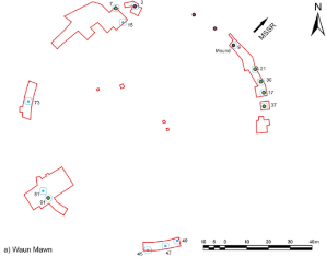
- At the site of a ruined cromlech at Waun Mawn (Welsh for bog), in the Preseli Mountains (Pembrokeshire, Wales), a stone circle of the same size as the Q and R bluestone circles at Stonehenge (110 m in diameter) has been identified:
It included the cavity of a stone (hole 91 of Waun Mawn) of pentagonal shape corresponding very closely to the pentagonal stone (stone 62) of Stonehenge.
The site had a north-east orientation towards the summer solstice like Stonehenge.
The researchers concluded from their observations (using optically stimulated luminescence [OSL] dating of the sediments in the cavities) that the stones at the site were removed 300 to 400 years after their erection in 3400/3200 BC, or about 3800/ 2800 BC, when human activity at Waun Mawn evidently ceased at the same time, for use at the Stonehenge site, where they were rearranged in their present locations and supplemented with local sarsenic sandstone. It was therefore deduced that the inhabitants of Waun Mawn may have migrated to Stonehenge taking their stones with them. As for the other stones, since not all of them come from Waun Mawn (notably the Sarsen), the hypothesis was formulated that stones from other sources could have been added to Stonehenge, perhaps from other dismantled circles in the region.
(2017 and 2018; excavations by Mike Parker Pearson’s team)
https://fr.wikipedia.org/wiki/Stonehenge
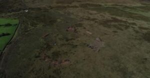
Waun Mawn site in the Preseli Hills, dismantled so that its blue stones could be reused at Stonehenge
https://www.cambridge.org/core/journals/antiquity/article/original-stonehenge-a-dismantled-stone-circle-in-the-preseli-hills-of-west-wales/B7DAA4A7792B4DAB57DDE0E3136FBC33
On the origin of the sarsen stones :
As for the origin of the sarsen stones, they have been shown to originate in West Woods, southwest of Marlborough.
Here is what we can read about the 9-month study conducted on this subject by geoscientist David Nash and his collaborator Timothy Darvill, archaeologist:
It is generally assumed that the sarsen were brought to Stonehenge from the Marlborough Downs, about 30 kilometers to the north: the nearest area has many sarsen blocks. However, the Marlborough Downs are huge, and we need greater precision to understand how prehistoric populations exploited the landscape and its resources. ” … ” Their results indicate that most of the megaliths would have originated at West Woods, southwest of Marlborough. With this new location, the researchers offer more evidence to determine what route would have been taken to transport the 30-ton blocks to their final destination. “We can empathize with the Neolithic people who took part in this collective effort and reflect on how they accomplished this herculean task. “
On orientation and the general link with the solstices
Like many other sites that have been studied, to which it is attributed an “agricultural and religious” function (sic), Stonehenge is one of the sites where an orientation towards the solstices and more particularly the winter solstice has been identified:
Stonehenge would more likely have been a place of ceremony and/or important gathering, notably during the summer solstice and especially the winter solstice, as suggested by more recent studies (the archaeologist Mike Parker Pearson has worked a lot on this question). In a Neolithic society where agriculture played a major role, the shortest day of the year must have had a very large religious and symbolic dimension.
https://www.sciencesetavenir.fr/archeo-paleo/archeologie/stonehenge-tout-savoir-du-site-megalithique-le-plus-celebre-du-monde-et-le-plus-mysterieux_149688
At the summer solstice, the first rays of sunlight cross the circle and strike the Heel Stone. At the winter solstice, the rays pass between the two triliths placed at the ends of the inner “horseshoe”.
In any case, many scientists agree that the precision of the locations of megaliths is too great to be the result of chance.
https://www.dinosoria.com/stonehenge.htm
The specialists studied several elements, including a nearby site called Durrington Walls, described by Prof. Pearson as “the largest Neolithic settlement in all of northern Europe”, with about 1,000 houses. But they also considered the presence of 80,000 cattle and pig bones. ” … ” Now, all of this seemed to testify to a great influx of people and activity at Stonehenge 5,000 years ago” … ” Analysis of livestock teeth shows a peak in the slaughter of young (spring-born) animals during the winter solstice, and to a lesser extent during the summer solstice.
At Stonehenge, several monuments have retained their alignment to the sunrise and sunset on the solstice, including the Stone Circle, the Avenue, Woodhenge, and the Durrington Walls Southern Circle and Avenue.
Although the original ceremonial use of the monuments is not known, they retain spiritual significance for some people who still gather near the two stone circles to celebrate the solstice and make other observations.
https://whc.unesco.org/fr/list/373/
On site and stone acoustics:
Dolerite from the Preseli Hills in Wales was used for the inner circle of Stonehenge. R. Till, an archaeologist studying the archaeoacoustics of Stonehenge and other places, notes that a village in this area is named Maenclochog, which means “ringing stones”. (ringing stones). Locally, it is well known that these stones have particular acoustic effects.
A place of burial by incineration
According to radiocarbon dating of cremated body remains, Stonehenge has been a burial ground since its creation five thousand years ago.
“It is now clear that Stonehenge was during all its great periods a burial ground,” says Mike Parker Pearson, an archaeologist at the University of Sheffield.
“The burial of cremated bodies dating from the Stonehenge monolithic period (…) shows that Stonehenge has always been the domain of the dead,” explains this professor of archaeology. Archaeologists estimate that the relics of 240 people could be buried on the megalithic site.
https://www.dinosoria.com/stonehenge.htm
A cremation site for an elite
Excavations undertaken in 2008 and the study of human remains, notably thanks to new carbon-14 dating, under the aegis of Mike Parker Pearson, Geoffrey Wainwright and Timothy Darvill, have brought elements that significantly modify our knowledge. It seems that as early as 3000 B.C. there was a burial necropolis, delimited by a first circle of bluestones and reserved for an elite, perhaps originating, like the stones themselves, from Wales where similar monuments are found among the most ancient
https://www.universalis.fr/encyclopedie/stonehenge/
A human sacrifice of an archer
In 1978, Richard Atkinson and his colleague John G. Evans discovered the skeleton of a Bronze Age man, known as the “Stonehenge Archer,” during a trench excavation in the circular enclosure. He was deliberately and carefully buried in the outer ditch, not in a barrow, as is typical in the region.
He was also not cremated like the others on site.
Radiocarbon dating suggests that he died around 2300 BC, making him roughly contemporary with other “archers” found in the vicinity, at Amesbury (Amesbury Archer) and Boscombe Bowmen
https://fr.wikipedia.org/wiki/Stonehenge
He would have been put to death by three arrows fired at short range, “…” Archaeologists have unearthed an archer’s wrist guard and arrowheads, including inside his body.
That’s why he was likened to an archer.
https://www.maxisciences.com/sacrifice/le-mysterieux-sacrifice-humain-de-stonehenge_art33673.html
Late Neolithic (2500BC) grave discovered in Wiltshire
In this grave, a woman was found in a curled up position with a piece of pottery, a fragment of a needle or spindle, as well as a hollow cylindrical object, cracked and made of schist comparable to a cup.
(discovery of the organization Wessex Archaeology)
A genre never before encountered by specialists.
“This is a unique object: we’ve never seen this before,” confirmed Dr. Matt Leivers, a consulting archaeologist with Wessex Archaeology, in a statement. “We can only speculate on its nature – it may have been a ceremonial cup deliberately damaged before being placed in the tomb.”
https://www.geo.fr/histoire/des-tombes-de-lage-du-bronze-exhumees-pres-du-site-de-stonehenge-203690